

Wednesday, August 30, 2006
One of the most remarkable aspects of England, in my opinion, is the extensive network of public footpaths that crisscrosses the country. Many of the footpaths cut directly across fields in which cows or sheep are grazing, and in which fresh cowpies, studded with amber flies, are a continual danger underfoot. Here in Warwickshire, most of the rural footpaths run along hedgerows in which hawthorn and blackberries predominate. In late August, the blackberries are at their peak of ripeness, in dark clusters in nearly every hedgerow.
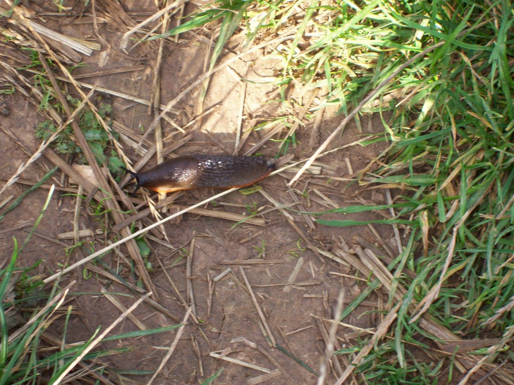
There is a popular misconception that everything is bigger in America than in England. This is certainly true of houses, cars, washing machines, and most other things designed to consume energy. But since our arrival in England, I’ve been compiling a list of things that are larger here than in America. At the top of the list are pigeons, blackberries, and slugs. The slugs are enormous—at least three inches long, glossy and black, with prominent antennae protruding from their front end.
At 9:00 on a Wednesday morning, we set out for a walk along public footpaths to Baddesley Clinton, about six miles to the west on foot, but nearly twice as far on the highway. We started out at Kenilworth Castle and followed a narrow gravel road called Purlieu Lane which eventually funnels into a dirt track passing between hedgerows that have grown together above the path to form a green tunnel. At the end of the tunnel, the path emerged into the open fields.
According to the latest census, the population of Great Britain stands at about sixty million people, which translates to a population density of more than 600 people per square mile. In the book Notes from a Small Island, Bill Bryson puts it like this: “to achieve the same density of population in America as in England you would have to uproot the entire populations of Illinois, Pennsylvania, Massachusetts, Minnesota, Michigan, Colorado, and Texas and pack them all into Iowa.” (The population has increased by another 12 million people since he wrote that.) Large towns like Kenilworth tend to be compact, unlike the sprawling suburbs of the United States. Every square inch of available land in the town is built on, and most of the people are packed into small terraced houses like ours: attached houses that share a common wall with their adjoining neighbors, each house a mirror image of the one beside it, each with its small walled-in back garden.
It’s remarkable, in such a densely populated country, that you can spend a full day rambling across public footpaths in almost complete solitude. Of course, this is not always the case. During high season in the Lake District, we encountered throngs of people on the six-and-a-half mile walk from Patterdale to Howtown along the southern edge of Lake Ullswater. But between Kenilworth and Baddesley Clinton, we encountered only a handful of people on the footpaths—a few joggers and cyclists, a few people walking dogs.
In the town, I’ve noticed, English people rarely smile or say good morning when you pass them on the sidewalk. They tend to return a friendly smile with a suspicious look, as if they suspect you of being slightly deranged. English people can seem unfriendly, even hostile, as if even a smile is an unwelcome encroachment on their private space. The one place I’ve found where this generalization doesn’t hold is on the public footpaths. On the footpaths, people usually say good morning, or at least return your smile with a grudging half smile of acknowledgment.
The ground we covered on our walk, like almost every square inch of English soil, is steeped in centuries of history. In the first open field we crossed we found two large concentric squares of mounded earth that are all that remains of the Pleasaunce, the moated pleasure ground built for a visit of Henry V to Kenilworth Castle in 1414. In the next field, hidden in the tall grass at the field’s margin, traces had been found of a Roman tile kiln. A mile further on, we came to the small eighteenth-century church in Honiley.

Honiley, it turns out, was originally part of the estate belonging to Simon de Montfort, the Earl of Leicester who held Kenilworth Castle in the mid-thirteenth century, and who was eventually killed in the baronial rebellion he led against Henry III in 1265. De Montfort built the original church in Honiley and dedicated it to St. John. Nearby natural springs, St. John’s Well and Our Lady’s Well, were frequently visited in the Middle Ages by pilgrims seeking absolution for conceiving children out of wedlock. And it was in Honiley that Richard Neville, Earl of Warwick—known as Warwick the Kingmaker—captured Edward IV during the War of the Roses. Now there is little to see in Honiley but the church, a few remaining outbuildings of the eighteenth-century manor house, a pub (The Boot), and the local “dog rehoming centre.”
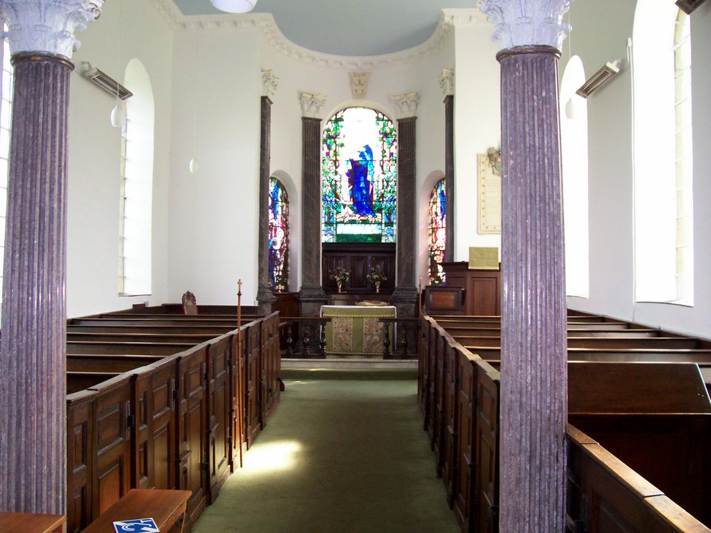
According to an inscription above the door, the present church of St. John in Honiley was built in 1723. The exterior of the church is unassuming gray stone, but the bright interior is clean and white, illuminated by the soft light from clear arched windows along the sides of the nave. In the small chancel, three arched windows of brilliant stained glass are framed by gray fluted pilasters topped with white Corinthian capitals, which echo the two Corinthian columns at the back of the nave. The effect is quietly stunning, and a surprising contrast to the dull gray stone and simple geometry of the exterior.
The construction of the new church was financed by John Saunders, who bought the Honiley estate in the early eighteenth century. One evening in 1723, according to local legend, Saunders dined with his neighbor, Sir Christopher Wren, and announced his intention to rebuild the local church, which had fallen into ruin since the days of Simon de Montfort five hundred years earlier. Wren, the story goes, asked for a pen and quickly sketched a design for the church on the white tablecloth. Saunders then had the church built according to Wren’s design. The legend is appealing, but it’s more likely that the church is the work of the Warwick architect Francis Smith, who designed the impressive west wing of Stoneleigh Abbey (1720-1726) and rebuilt much of Warwick itself after the great fire of 1694.
From Honiley, we walked down a country lane to the small hamlet of Wroxall. Wroxall Abbey—originally the site of the twelfth century priory of St. Leonard—was purchased by Sir Christopher Wren in 1713 as a wedding gift for his son, and Wren himself lived there, in the old Elizabethan manor house, until his death in 1723. On our walk, we bypassed Wroxall Abbey, and the old church containing memorials to several generations of the Wren family, and after a short jog down the busy Birmingham Road headed out across a field to Hay Wood.
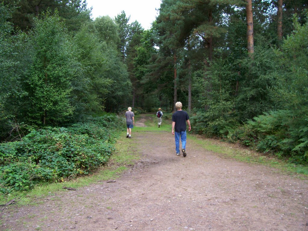
Hay Wood is a fragment of the ancient Forest of Arden. In the Archive Room at Baddesley Clinton hangs a map of the estate drawn in 1699, by which time the estate had been in the Ferrers family for six generations. The boundaries of Hay Wood on that late seventeenth-century map are nearly identical to the boundaries as they appear on the 2006 Ordnance Survey map. Already, three hundred years ago, deforestation had reduced the Forest of Arden to small fragmented woods and copses like Hay Wood. The wood is disappointing for anyone expecting Shakespeare’s romantic greenwood. On our walk, we followed a wide, muddy track through the woods, through bracken and past pine plantations in staggering rows, which reminded me that Hay Wood is now a managed forest. At least the woods were quiet: we had finally come out from under the flight paths of planes landing at Birmingham International Airport.
In the Middle Ages, the Forest of Arden was deep and dangerous, full of wild beasts and marauders who posed a constant threat to life and property. Before the Norman invasion, the Saxons grazed their cattle in clearings in the woods, often surrounded by a defensive ditch. After the Normans came into possession of the land in 1066, farms and manor houses were often built in these clearings, and the defensive ditches were often elaborated into moats. Such was the case at Baddesley Clinton. The estate was originally a forest clearing belonging to a Saxon named Baeddi—hence the name Baeddis Leah, or Baeddi’s Clearing—which passed into the hands of a succession of Norman families, including the de Clintons, who came into possession of the estate in the late thirteenth century.
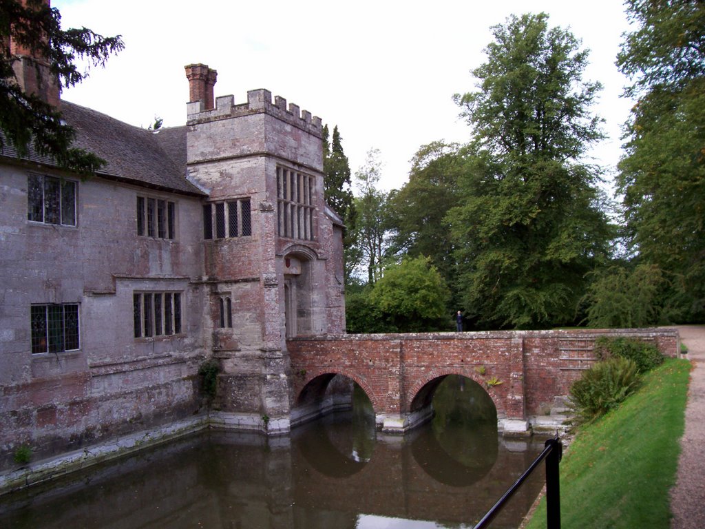
Fifteen generations of the Ferrers family are buried in the small church that stands on the path between Hay Wood and the Baddesley Clinton manor house. The Ferrers remained a steadfastly Catholic family after the Reformation, and in the 1590s, Henry Ferrers (“the Antiquary”) rented the house to the intrepid Anne Vaux. In the Protestant England of Elizabeth I and James I, Catholic priests were outlaws, subject to imprisonment and torture if discovered, so during her tenancy Anne Vaux had Baddesley Clinton remodelled to include several cunningly concealed hiding places where Catholic priests could hide from priest hunters (or “pursuivants”). Two of these “priest holes” are visible on the tour of Baddesley Clinton—one in the kitchen, in the shaft of a medieval garderobe, and one in the moat room. In October 1591, five priests and several lay brothers hid for hours in these hiding places while pursuivants ransacked the house.
No comments:
Post a Comment